


Going South to North
Prior to Eisenhower's Interstate Highway Act of 1956, US Highway 191 was one of the longest North-South routes across the western United States. Beginning in Arizona and ending at the Canadian border in the town of Loring, Montana, US 191 intersects and straddles much of our country's scenic backbone called the 'Continental Divide'.
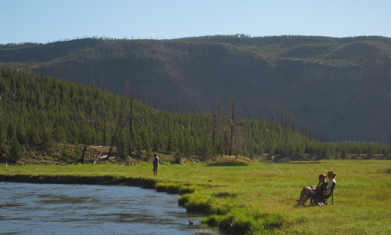
My favorite portion of this road begins 150 miles south of Yellowstone, as you decend the scenic vista atop the prairie just south of Boulder, Wyoming, about 20 miles south of Pinedale. There you have an unfettered view of Wyoming's largest mountain range, the Wind Rivers, flanking the eastern horizon, while you pass by two of the state's premier trout rivers, the Green and New Fork.
Pinedale has a tradition dating back to the early 1900s as one of the most prolific cattle ranching areas of the frontier west, and sports some of the largest ranches and cattle operations still in existence. With elevations 7000 ft. and higher, this sub-alpine valley is lush and green from mid May through July before warm summer temperatures dry area grasses. Besides seeing herds of pronghorn Antelope dozens strong, Angus and Hereford cattle dot the landscape for miles around, providing excellent opportunities for capturing images of the true American West.
Traveling 43 miles north of Pinedale you pass through the hamlet of Bondurant, gateway to the southern boundary of the Gros Ventre Wilderness. Long known as a big game hunter's paradise, these mountains provide excellent opportunity to see Rocky Mountain bighorn sheep, elk, moose and trophy mule deer. The beautifully sinuous Hoback River flows through this scenic valley and follows the highway for 21 miles until it reaches the confluence with the Snake River at the enclave known as Hoback Junction.
Highway 191 continues north along the Snake River for roughly 4 miles until you enter the South Park portion of the Jackson Hole valley. As one approaches the South Park bridge (which crosses the Snake), visitors get their first glimpse of the Teton Mountain range. Though the famous Teton peaks are not yet in sight (obscured by local buttes in the foreground), some of America's most famous pastoral ranch scenes begin to unfold as you approach the city of Jackson Hole.
With a year-round population nearing 9,000 permanent residents, Jackson Hole (in summer) can see upwards of 25,000 visitors come through its area in a single day. To be a pedestrian walking across US 191 on the famous "Town Square" intersection around 4:00pm on a July day can be compared to crossing Wilshire Blvd to get to Santa Monica Pier in California. This truly is a spot for people watching. Cultures from all over congregate on the Jackson Town Square to enjoy the clean mountain air, the frequent art festivals, unique retail shops and incredible selection of cuisine.
Having lived in this beautiful community for 21 years, I can say unequivocally that Jackson Hole has more variety of amenities, services and activities from which to enjoy than any town of its size in the northern Rockies. With that being said, there still are jewels to discover as we head northward.
Just 5 minutes outside of town, as you pass the National Elk Refuge to the east, the Teton peaks first come into view. As this happens, turn off immediately to your right into the turnout that features the "Welcome to Grand Teton National Park" sign and capture the moment on film (or memory card) with your traveling companions. This is a moment to savor, to remember for all eternity. Many a time I have been in this location and seen the conversion of travelers who first witness this magnificent mountain range saying "this truly is God's country".
After you compose yourself and consume enough megapixels to make even Bill Gates proud, enjoy the rest of the drive through the Teton Park scenic corridor. You'll soon pass the Jackson Hole Airport (the only one in the US located inside a National Park) prior to approaching the southern entrance to the Park at Moose, Wyoming.
Here you can see the magnificent interpretive displays at the Honorable Craig Thomas Visitor Center, enter the interior of the Park through a fee entrance station, take an enjoyable float trip on the Snake River in the Park, catch a fine-spotted Snake River cutthroat trout (native only to this river system), and see wildlife such as antelope, moose, elk, deer, osprey, eagles and the perennial local favorite, the 'chiseler'. Local's Tip: when in Moose, visit Dornan's Wine Shoppe. They serve up a mean Pinot Noir!
Continuing north from Moose, you pass by the Antelope Flats section of Grand Teton National Park, always filled with bison, the occasional moose and inquisitive coyotes. In more recent years, re-introduced wolves are regularly seen following herds of elk moving to and from their seasonal grounds. Though the wolves often blend in with local sagebrush at a distance, you know they are in the area when you see elk herds on the move for no apparent reason.
About 7 minutes north of Moose, you approach the famous Snake River Overlook, made photographically famous by legendary photographer Ansel Adams for capturing his unforgettable black and white image of the Snake River in 1942. This location is worth the stop to pay homage to all things panoramic. It will take your breath away. All along the rim of this glacial moraine, you'll enjoy multiple opportunities (and pullouts) from which to capture your image of a lifetime. Local's Tip - have backup batteries, and for the best early morning alpen glow images of the Tetons, arrive at the overlook 30 mins before sunrise, have a strong tripod for your camera, and be ready to capture pics every minute or so for best coverage of light.
Further up the road you'll encounter the Triangle X and Buffalo Valley pastures - grassy meadows near the town of Moran - which is Grand Teton Park's northern fee entrance. In summer, herds of bison can be seen grazing and dusting themselves interspersed with the occasional antelope and moose. It is here that some of Jackson Hole's most famous guest ranches started, and continue to operate today. My favorite is the Triangle X, established by the Turner Family in 1926. A finer kid's horseback riding program you will not find, nor T-bone steak! if you go, get the 'Snake River Dinner Float Trip' which combines a delicious western BBQ dinner and raft trip on the Snake. A word of warning: enjoyment of this trip is habit forming and may cause frequent yearnings to call your travel agent every January saying "I need my Snake River fix"!
Another of the Tetons' more famous photographic pullouts can be found just 5 miles inside the Moran entrance as you travel north toward Yellowstone. Here you'll see the picturesque and reflective waters of Oxbow Bend, a quiet side channel of the Snake River as it flows out of Jackson Lake. Regardless of time of year, it is not uncommon to spot moose feeding it its weedy willow bottoms, or watch the aerial acrobatics of hungry osprey compete with their larger bretheren, the bald eagles, for tasty trout. This slow water is also the perfect location for recreational kayak and canoeists to enjoy a leisurely paddle. Just don't be surprised to see a family of otters swimming by. A word to the wise: utilize a waterproof cover for your camera or smartphone.
Past Oxbow bend another 2 miles is the entrance to Jackson Lake Lodge (JLL), the crown jewel of lodging properties and recreation on Jackson Lake inside Grand Teton Park. Stepping into their lobby for the first time, you'll be amazed at the large picture windows perfectly framing the Grand Teton peaks. From enjoying lattes and Chardonnay on the balcony overlooking Moose Flats, to taking wildflower hikes, horseback rides or boat tours on the Lake, this facility will leave you in awe.
After enjoying some time at JLL, your trip along Hwy 191 takes you past Colter Bay and Leeks Marina, the 'liar's den' for fishermen who want to 'one up' each other. Fact: the largest lake trout in Wyoming was caught in Jackson Lake in 1983 - 50lbs.
The 191 Highway now meanders through stands of lodgepole pine and aspen for several miles before opening up one last time at a scenic overlook on the northern-most shore of Jackson Lake. This is your last glimpse of this fabled reservoir, complete with amazing views of what now seems like a compacted Teton Range. Your journey continues north, climbing several hundred feet in elevation to then enter the John D. Rockefeller Memorial Parkway, a 5-mile long scenic buffer between Grand Teton and Yellowstone National Parks named after the Standard Oil magnate of the 1920's credited with helping the National Park Service purchase and protect lands in the Jackson Hole valley that would eventually be donated to the Park Service to expand into present day Grand Teton National Park.
Yellowstone Park's South Entrance - 150 miles later
When one considers a picture-perfect setting from which to enter a national park for the first time, one only needs to experience the drive-up to the south entrance. Flanked by the Snake River on the east side of the road, your entry into Yellowstone is simultaneously serene and surrealistic. As you travel north, you climb in elevation to over 8000 ft. passing over flowing steams and waterfalls, through dense forests and the magnificent Lewis River Canyon, named after famed explorer Meriwether Lewis. From atop this canyon plateau, you see the charred remnants of the infamous 1988 Yellowstone Fire that destroyed nearly 1/2 of the parks forested acres. Now decades later, those early seedlings spawned from the fire are naturally regenerating incredibly lush canopies of lodgepole pine and fir, making for what will become a new renaissance in Yellowstone's colorful history.
The winding park road now moves past Lewis River falls, Lewis Lake and the first of several crossings over the Continental Divide, geologic points of interest where runoff waters ultimately flow either to the Pacific (via the Snake and Columbia river systems), or the Missouri headwaters (ultimately destined for the Gulf of America). Along Highway 191 inside Yellowstone, you cross the divide multiple times inside of 20 miles, a rather unique fact.
The first major intersection you encouter along this road is found at West Thumb, which accesses the eastern portion of the lower loop that follows the western shore of Yellowstone Lake. Continuing straight through this intersection eventually gets you to the Old Faithful Geyser Basin, home of the world's most famous geyser, Old Faithful. With its eruptions happening, on average, every 68-70 minutes, it is one of the most consistent natural spectacles known to mankind. While here, you owe it to yourself to explore the boardwalks and trails around this thermal basin, if only to experience the awe and wonder of mud pots, sulfuric smells, spontaneous rainbows created by high-pressure steam and spray, and the looks on faces of people from around the world who have never seen such beauty and excitement.
The main river flowing through this basin, appropriately called the "Firehole River", leads Hwy 191 downstream as it passes numerous other geyser basins small and large. Along the way you'll see open meadows which often spotlight native wildlife including moose, deer, bison, bear, waterfowl, elk and, if you're lucky, newly introduced wolves. Roughly 15 miles downstream from where you initially crossed the Firehole, that river name gives way to its merging cousin, named after our Secretary of State in 1803 when Lewis & Clark discovered the Northwest Passage, the (James) Madison River.
The Madison, itself, isn't really its own river, but amasses the flow of two converging rivers, the Firehole and the Gibbon, at the Madison Junction. It is at this junction that Hwy. 191 now turns left (west) and follows the Madison River out the west entrance of the Park. Passing some of the most beautiful riparian lands in all of America along the way, this river corridor is uniquely special. Flanked by spectacular cliffs hundreds of feet high, the Highway winds its way for 12 miles before reaching the park's west gate and the friendly town of West Yellowstone.
Leaving the Park - following the Gallatin River
In history, certain cities have been bestowed with slogans that we all remember. Examples: Chicago, 'the Windy City', New York City, the 'City that Never Sleeps', or Paris: the 'City of Romance'. For West Yellowstone, it has been given two unique distinctions for outdoor recreationalists: in summer it is known as 'the Trout Capital of the US' and in winter as the 'Snowmobiling Capital of the US'. What's not to love?
Owing to its early success as the end of the line for the Union Pacific railroad coming up from Idaho and Utah starting in 1908, visitors to Yellowstone came via rail through West by the thousands. By the 1960s, the rail line was all but defunct, but due to America's new found love of the automobile, West Yellowstone and Hwy 191 experienced a re-birth. Today, hotels, cabins, lodges, attractions and shops of all kinds line the streets of this quiet town, providing a fun and enjoyable homebase for Yellowstone visitors the world over.
Following Hwy 191 north, you climb out of the Hebgen Lake valley and follow Grayling Creek through Yellowstone Park until the road's plateau leaves the Grayling drainage and begins following the very headwaters of the Gallatin River. The Gallatin - named after Thomas Jefferson's Secretary of Treasury, Albert Gallatin in 1803 by the Lewis & Clark explorers - is one of the three rivers to eventually form the headwaters of the Missouri River, explored and charted by Lewis & Clark during the Corps of Discovery in 1803-05. Of all the scenic drives in the Rockies framed by a wild flowing river, this is one to be cherished and appreciated.
Whether you ride a bicycle, or drive a car, motorhome or motorcyle, this route has plenty of turnouts from which to take pictures and take-in the magnificent sites. One thing you'll notice right off is the clarity of the water, save for spring runoff. Running surprisingly clear and cool all summer, this river is a favorite for angler and kayaker/rafter alike. Wildlife, fisheries and botanical biologists all concur that this Hwy 191 corridor is one of the most in-tact and unique ecosystems found in the overall Yellowstone ecosystem. It is why new residents have moved here in good numbers since the late 1990s, to enjoy a quality of life found in relatively few areas of the U.S.
Though large trucks are allowed to drive the canyon for normal commerce, Federal Law prohibits any loads considered "hazardous" from traveling this route, thus helping to ensure that this river system is protected from any major environmental accidents. It also means when driving this scenic route, one need pay attention to your speed, not for going too fast, but to pull off in a turnout if you are going too slow. Believe me, the scenery and natural wonders found here will have you pulling out often if only to witness something new and breathtaking you didn't see previously.
From the time you leave the Yellowstone Park northern boundary, Hwy 191 winds down roughly 15 miles to the town of Big Sky, home to incredible public skiing (at Big Sky Resort), as well as private resorts such as the Yellowstone Club. Though considered ritzy by some, the developers of these projects have been very cognizant of their development impacts and have gone to great lengths to provide quality surroundings for both humans and the native wildlife. It is well worth your while to spend a day or two in Big Sky and see how enviro-friendly land stewardship can be done right.
As you leave Big Sky and continue to follow the Gallatin River, watch for bighorn sheep along mountainsides. In winter, these majestic animals are along the highway's shoulders; in summer they are along cliff faces in the canyon. Roughly 25 miles down the road, you exit the Gallatin River canyon and enter the Gallatin Valley, home to the communities of Gallatin Gateway, Manhattan, Amsterdam, Belgrade and Bozeman, another 18 miles away.
Cumulatively, these towns have a population approaching 85,000 people, spread out over hundreds of square miles. Hosting one of the original land grant universities established back in 1893, Montana State University is based in Bozeman and is nationally-renowned for its bio-tech virus research inside Yellowstone, for its architecture, engineering, accounting, nursing and business schools, as well as being the 'best school for learning fly tying' by some students who will remain anonymous! Or, to put things into 'trout perspective' in another fashion, fly fishing manufacturer SIMMS FISHING PRODUCTS, based in Bozeman, notes that more fishing guides and drift boats exist within a 50 mile radius of this community than anywhere else in America. Prime testing ground wouldn't you say?
Highway 191 at 'Four Corners' merges with Montana State Highways 84 and 85, then jogs east to eventually connect with Interstate 90 on the east end of Bozeman. All told, from Pinedale to Bozeman, a driver will cover roughly 310 miles, but in this writer's opinion, these are some of the most beautiful miles a person will ever want to experience when visiting the greater Yellowstone area.